Russian scientists, together with their German colleagues, explained the peculiarities of the formation of urban heat islands. It turned out that they are caused by the synergistic effect of mesoscale, several kilometers, heat spots, and not at all a simple sum of small local zones, several hundred meters long. The authors' findings will help to better predict urban climate change and plan urban beautification. The results of the study, supported by a grant from the Russian Science Foundation (RSF), are published in the journal Frontiers in Environmental Science.
In megacities, the temperature is always higher than in the countryside, and this effect is called a heat island. At the same time, the territory of the city consists of different areas (parks, industrial zones, residential areas, etc.), which make a different contribution to the overall warming. As a rule, in their studies, scientists compare temperatures between climatic zones - areas less than one kilometer. This approach is good when you need to explain patterns on a small scale, but not on a global scale, for example, when describing an entire metropolis. Such a system turns out to be much more complicated.
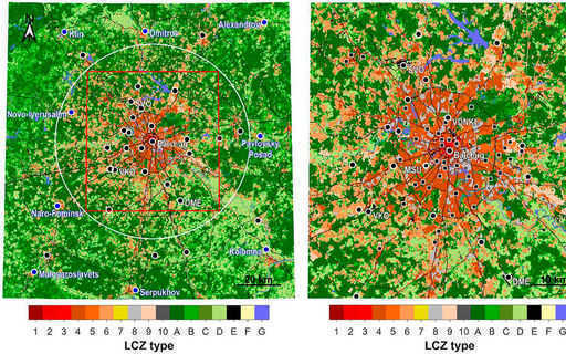
Scientists from Peoples' Friendship University of Russia (Moscow), Lomonosov Moscow State University (Moscow), Moscow Center for Fundamental and Applied Mathematics (Moscow) with colleagues from Ruhr University in Bochum (Germany), Freiburg University (Germany) and Berlin Technical University (Germany) found that a significant contribution to the urban heat island is made by inhomogeneous areas with a scale not of hundreds of meters, but much larger. The study was based on data from state monitoring networks, as well as from "people's weather stations" of the Netatmo network in Moscow and its districts. Thus, the authors had more than one and a half thousand points at their disposal, the values for which were compared with the types of local climatic zones.
The effect of the heat island is most pronounced in areas of dense mid-rise buildings and multi-storey residential complexes, while territories of the same type have different temperatures depending on the environment: the maximum was in the city center and the minimum was among the green areas. From this, the authors concluded that each specific heat spot is due to factors not on local territories, but on mesoscale, that is, with a radius of up to 10 kilometers. In such areas, atmospheric flows play an important role, redistributing heat.
“Our research has shown that along with the peculiarities of the development of individual quarters and micro-districts, it is necessary to take into account the heterogeneity of the territory on the scale of the entire city or its large districts. This makes it possible to better understand and predict the spatial picture of the heat island in the tasks of weather forecasting, assessment of thermal comfort and urban planning. In the future, we plan to investigate how the rate and direction of atmospheric transport affects the heat island, ”said Mikhail Varentsov, PhD in Geography, Researcher at the Research Computing Center of Moscow State University and the Smart Urban Nature Science Center at the RUDN Agricultural Institute.
bbabo.Net